Cities4PeopleCities4PeopleCities4PeopleCities4People
  • Hakkımızda
    • Hedeflerimiz
    • Yaklaşımımız
    • Aktivitelerimiz
    • Kavramsal Temellerimiz
    • Konsorsiyumumuz
  • Pilot Bölgeler
    • C4P Hareketlilik Laboratuvarı
  • Haberler
    • Haberler
    • Etkinlikler
      • Geçmiş Etkinlikler
      • Gelecek Etkinlikler
    • Bülten
  • Kaynaklar
    • Vatandaş Hareketlilik Malzemeleri
    • Proje Logosu
    • C4P Raporları
    • C4P – Medya
      • Poster
      • Broşürler
      • Fotogaleri
      • Videolar
  • İletişim
  • Turkish
    • English English
    • Magyar Magyar
    • Ελληνικά Ελληνικά
    • Deutsch Deutsch
    • Turkish Turkish

Oxfordhsire, İngiltere

  • Oxfordhsire, İngiltere
  • Altona’nın Hamburg Bölgesi, Almanya
  • Üsküdar, İstanbul, Türkiye
  • Bdapeşte, Macaristan
  • Trikala, Yunanistan
  • Trikala (GR)
  • Oxfordshire (UK)
  • Istanbul (TR)
  • Hamburg (DE)
  • Budapest (HU)
Home Pilot Bölgeler Oxfordhsire, İngiltere

Maalesef bu sayfa yalnızca İngilizce dilinde mevcuttur. Lütfen iletişim kurmak ve daha fazla bilgi edinmek için iletişim bilgilerimizi kullanmaktan çekinmeyiniz. Sorry, this entry is only available in Amerikan İngilizcesi, Macarca and Almanca. For the sake of viewer convenience, the content is shown below in this site default language. You may click one of the links to switch the site language to another available language.

Oxfordshire, UK

The pilot area

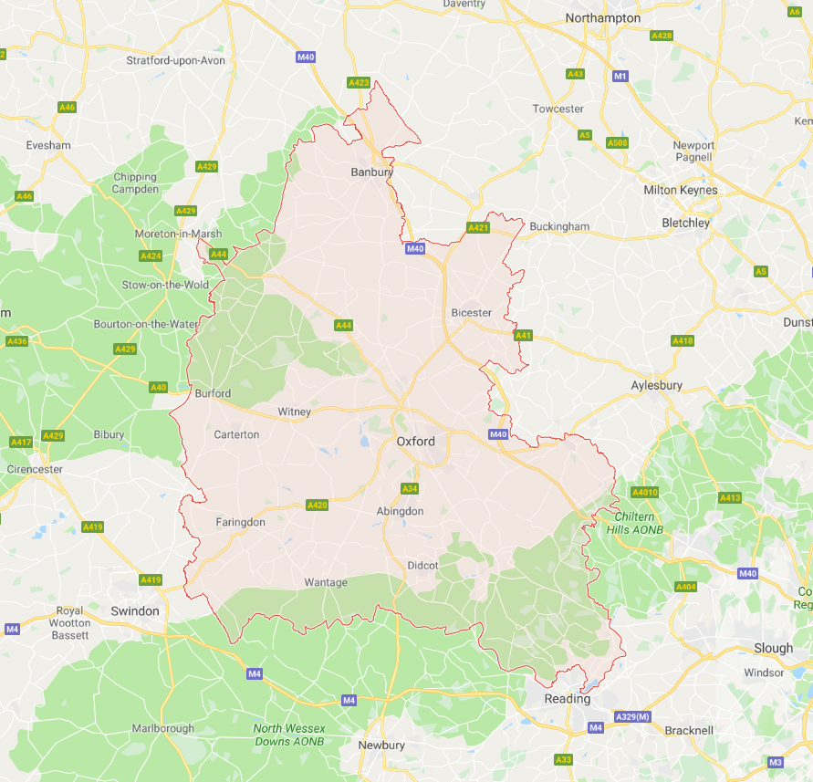
Oxfordshire is a prosperous and vibrant county, combining a thriving economy with a high-quality environment. It is the most rural county in South-East England, and yet a world leader in innovation and enterprise in areas such as life sciences, space technologies, electronic & sensors, creative & digital and automotive.

Oxford is the 52nd city in size and one of the fastest growing in the UK. However, as with many medieval European cities, Oxford faces significant issues in delivering holistic and connected mobility due to its densely-built and narrow streets. This is exacerbated by development restrictions, Green Belt zoning and flooding considerations, resulting in a lack of inter-neighbourhood connectivity. The area of the Eastern Arc, which has recently become the largest employment location within the Oxford locality, faces several urban mobility challenges with the most serious being: i) the insufficient transport network, ii) congestion at peak hours, and iii) constrained housing supply and increasing unaffordability. Limited accessibility and a disconnected transport network led to a substantial use of private cars, which in turn caused increased road congestion. A legacy of deregulation and privatisation of public transport has only increased the problem, since it brought about fragmentation and significant challenges to delivering sustainable, low-carbon, low-cost, end-to-end transport solutions.

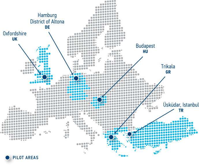
Improving the transport network within the Eastern Arc is key to Oxford’s economic and social success. Good quality, reliable transport has an major role to play in supporting regeneration and growth by providing opportunities for reaching and accessing employment, training, essential services and amenities. How can this be achieved? As each community is unique, no Citizen Mobility Lab or Kit looks exactly like the others.

At Oxfordshire, we are using this. What is going on in our Lab you can find out here instead.

Don’t forget to have a look at local news and updates and check who else is active in the area.

Transportation policies

Both at the local and at the national level, an increased investment in public transport and a greater focus on people’s quality of life characterises British transport and mobility. In 2017, the UK Department of Transport published a Cycling and Walking Strategy Investment document as well as its Transport Investment Strategy document “Moving Britain Ahead”, which describes how future government transport investment decisions should aim to, among others, create a more reliable, less congested, and better connected transport network. The latter should enable people to access employment and services on the whole territory, while also protecting the environment and encouraging healthy lifestyles.

The Transport Investment Strategy also identifies the need to combat climate change, improve air quality, and manage wider impacts on the environment, such as transport noise, damage to natural habitats and cultural heritage. The UK’s approach to these challenges is through investment in innovation, research and technology, including investments in the areas of ultra-low emission, and connected and autonomous technologies. Overall, three objectives are aimed for by 2040: better safety, better mobility and better streets. Contributions from local authorities and the empowerment of local people to shape their surroundings are crucial to promote a greener, sustainable regional transport infrastructure (e.g. through Sub-national Transport Bodies – STBs).

In the UK, local governments have power over local urban planning, including transport services. The Oxfordshire County Council developed a new transport strategy in 2015, which identified 7 economic, social and environmental elements that have an impact on transport and mobility needs: Oxford’s growing and changing economy; the economic growth in new locations; economic and health inequalities; rapid population growth and demographic change; increased daily travelling into Oxford and changing travel patterns; increasing need for housing and need for new high-quality neighbourhoods; lacking balance of different needs in the city centre; urban environment and air quality.

The Oxford Transport Strategy (OTS) 2015-2031 supports inclusive economic growth through measures that help reduce pressure on the road network, limit emissions and promote active and healthy travel. Cycling and walking are encouraged and the Oxfordshire County Council plans to provide better integrated, high-quality public transport, and improve road safety. Neighbourhood Plans developed by local communities should be consistent with the overall region’s transport strategy.

Overview

> Explore map

Quick facts

POPULATION

Oxford: 159,600 inhabitants (2015)
Oxfordshire County: 688,410 inhabitants (2016)

LAND AREA

Area: 45.59 km²
population density: 3270/km²

  • Hakkımızda
  • Pilot Bölgeler
  • Vatandaş Hareketlilik Malzemeleri
  • C4P Hareketlilik Laboratuvarı
  • Haberler
  • Kaynaklar
  • İletişim
  • Gizlilik Politikası
  • Impressum

This project has received funding from the European Union’s Horizon 2020 Research and Innovation Programme under grant agreement No 723194.

Copyright 2017 Cities4People | All Rights Reserved                             Read our privacy policy                             Impressum
  • Hakkımızda
    • Hedeflerimiz
    • Yaklaşımımız
    • Aktivitelerimiz
    • Kavramsal Temellerimiz
    • Konsorsiyumumuz
  • Pilot Bölgeler
    • C4P Hareketlilik Laboratuvarı
  • Haberler
    • Haberler
    • Etkinlikler
      • Geçmiş Etkinlikler
      • Gelecek Etkinlikler
    • Bülten
  • Kaynaklar
    • Vatandaş Hareketlilik Malzemeleri
    • Proje Logosu
    • C4P Raporları
    • C4P – Medya
      • Poster
      • Broşürler
      • Fotogaleri
      • Videolar
  • İletişim
  • Turkish
    • English English
    • Magyar Magyar
    • Ελληνικά Ελληνικά
    • Deutsch Deutsch
    • Turkish Turkish
Cities4People